Navigation
Shaped by Experience
AI-powered vessel routing that reflects how vessels actually move
Features
We build region-specific AI models trained on real AIS data to learn the behaviour of
different vessel types. This enables highly realistic forecasting of vessel movements
between flexible locations, delivering unmatched precision and reliability.
Request a Free Trial
Usage
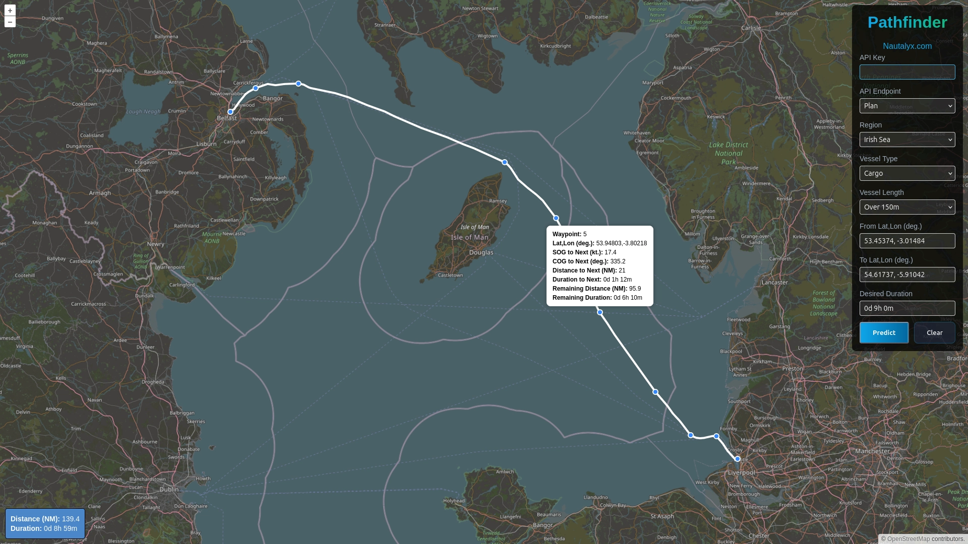
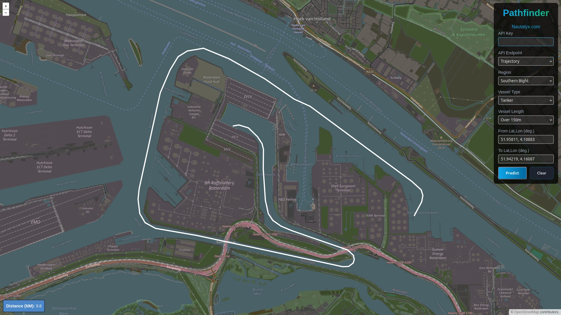
Generate single predictions through Pathfinder, our no-code, browser-based interface, or integrate directly with our low-code APIs:
-
Trajectory - predict the most likely route a vessel will take to a destination
-
ETA - estimate arrival times with data-driven confidence bounds
-
Plan - generate fuel-efficient passage plans aligned with a target transit time
To find out more about our APIs, visit our Documentation.
Local Precision
Region-specific models capture local constraints, traffic patterns, and navigational behaviour in detail to mirror real-world vessel movement.
AIS-Powered
Models are trained on carefully processed AIS data to accurately represent the behaviour of different vessel types.
Effortless Integration
Generate predictions instantly in Pathfinder, or embed our models into existing systems using low-code APIs.
Always Current
Models are continuously refreshed with the latest AIS data to stay aligned with evolving patterns and constraints.
Use Cases
Our region-specific AI models support any application that requires accurate and reliable vessel movement predictions within a defined area.
Port Operators
Optimise berth allocation and reduce disruption with continuously updated ETAs during final approach to a chosen location, such as a pilot boarding station or specific berth.
Vessel Tracking
Enhance situational awareness by integrating future trajectory predictions into tracking and monitoring systems.
Autonomous Vessels
Validate and benchmark navigation systems, or embed our models to support reliable routing in complex and constrained environments.
Models
Explore our deployed region-specific AI models, as well as those under
development.
Request a Region
if it is not listed below.
English Channel
LIVE
North: UK coastline
South: FR coastline
East: Strait of Dover
West: Celtic Sea
Irish Sea
LIVE
North: Arran Island (UK)
South: St. George's Channel
East: UK coastline
West: IE and UK coastlines
Mississippi Delta
LIVE
North: 40NM north of Baton Rouge (US)
South: 50NM offshore
East: Cat Island (US)
West: Marsh Island (US)
Salish Sea
LIVE
North: Cortes Island (CA)
South: US coastline
East: US and CA coastlines
West: Pacific Ocean
Southern Bight
LIVE
North: 30NM offshore Flamborough Head (UK) and Texel (NL)
South: Strait of Dover
East: Rotterdam (NL) and Antwerp (BE)
West: Thames Estuary (UK) and Humber Estuary (UK)
UK Rollout
PENDINGUS Rollout
PENDINGAbout
Different vessel types behave differently. Tankers, container ships, ferries, and tugs
operate at different speeds and under different constraints. That’s why established routing
systems separate models by vessel type and size - using a single model for all vessels
leads to inaccurate results in practice.
The same principle applies to geography for the same reason. Every waterway has its own
navigational patterns and practical constraints that shape how vessels move, including
narrow channels, port approaches, traffic separation schemes, and local operating practices.
Just as vessel type matters, so does location.
In reality, achieving global coverage requires models to simplify or generalise these
regional details due to data, computational, and operational constraints. This reflects a
fundamental modelling trade-off: prioritising coverage means sacrificing detail. Attempts
to add complexity to mitigate this often produce models that are difficult to deploy,
challenging to interpret, and time-consuming to update.
This trade-off becomes critical as vessels approach their destination or operate in
constrained environments, where small errors have outsized operational consequences such as
costly delays or safety risks. In these situations, regional factors dominate vessel
decision-making - dictating timing, limiting routing options, and forcing real-world
adjustments.
Global models struggle to capture this nuance. We don’t.
We build region-specific AI models trained on real vessel behaviour derived from AIS data,
capturing local navigational patterns and constraints in great detail.
Our modular regional design delivers practical advantages that global architectures cannot
match. We can retrain and deploy updates to individual regions in hours rather than weeks,
responding rapidly to changing conditions, new regulations, or emerging patterns. Our
models are computationally efficient, enabling deployment on edge devices when
needed. Most importantly, our models remain transparent and interpretable.
We specialise our models not only by vessel type and operational context, but by geography,
ensuring predictions are finely tuned to the reality of how vessels actually move.